
Slick Roads Possible This Morning as Winter Weather Advisory Continues
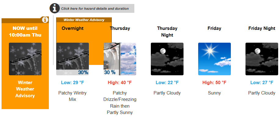
A Winter Weather Advisory remains in effect this morning across the Sandhills, with freezing rain and icy patches still possible, especially on untreated roads, bridges, and sidewalks.
According to the National Weather Service in Raleigh, light ice accumulations around a thin glaze developed overnight and may continue to cause hazardous travel conditions early today, particularly for the morning commute.
The advisory is scheduled to expire at 10 a.m., as temperatures slowly climb above freezing.
What to Expect Today
- Freezing rain possible early this morning
- Cloudy start, gradually becoming mostly sunny
- High temperature near 39 degrees
- Wind chills as low as 20 degrees
Even as sunshine returns later today, shaded and secondary roads may remain slick longer, especially in Moore, Richmond, Scotland, Hoke, Montgomery, and Anson counties.
Travel & Safety Impacts
The National Weather Service warns that roads, bridges, and overpasses may remain icy, even after precipitation ends. Drivers are urged to:
- Slow down and allow extra stopping distance
- Watch for black ice in shaded areas
- Use caution on sidewalks and parking lots
- Check road conditions by calling 511
Residents should also be prepared for isolated power outages, though widespread issues are not expected.
Improving Conditions Ahead
Weather conditions improve steadily moving forward:
- Tonight: Partly cloudy, low near 22
- Friday: Sunny and milder, high near 49
- Saturday: Sunny and cold, high near 43
- Sunday: Partly sunny, high near 45
- Monday: Mostly sunny with a warmup, high near 59
No additional winter weather advisories are currently expected after this morning.
Stay Connected
Continue to check back with Star 102.5 FM and the WIOZ First Alert Weather Desk for updates on changing conditions, school schedules, and local impacts across the Sandhills.